The CZCS data were transmitted from the spacecraft to ground receiving stations at a rate of 800 kbs either in real time or via playback of the onboard tape recorder. The tape recorder was utilized when the spacecraft was out of the range of ground tracking stations. Due to the power demands of the various on-board experiments the CZCS sensor was operated on an intermittent schedule and collected data only two hours per day on the average.
Due to the power demands of the various on-board experiments, the CZCS sensor was operated on an intermittent schedule. In 1981, it was determined that the sensitivities of the CZCS was degrading with time, the 443nm band in particular. Sensitivity degradation was persistent and increased during the rest of the mission. In mid-1984, Nimbus-7 mission personnel experienced turn-on anomalies with the CZCS system, which were related to power supply problems. Spontaneous shutdown of the CZCS system began occurring as well, and persisted for the rest of the mission. From March 9, 1986 to June, 1986, the CZCS system was given highest priority for the collection of a contemporaneous data set of ocean color. It was turned off in June 1986 at the start of the low power season with the intention of turning it back on in December when power conditions would be more favorable. Attempts to reactivate the CZCS system in December 1986 failured. The CZCS sensor was officially declared non-operational as of 18 December 1986.
During the 91 months of its operation (October 1978 - June 1986), CZCS acquired nearly 68,000 images. Many of these images were duplicates from near-by ground stations and/or on-board recorded data. The OBPG has processed the L1A data from these 68,000 images to reduce duplicate data and combine the files by orbit, resulting in approximately 15,500 'MLAC' data files.

Because CZCS shared power and data recorder storage with the other instruments on Nimbus-7, data collection was not uniform in time or space. It was originally estimated that the CZCS would only have a 10% duty cycle and was never intended to provide the kind of consistent, global sampling that we have become accustomed to with SeaWiFS and MODIS. To get an idea of the spatial and temporal density of sampling that CZCS acquired as compared with SeaWiFS, the plot below shows a timeline of the percentage of coverage obtained by CZCS, normalized against the representative monthly coverage from SeaWiFS. The assumption is that a monthly SeaWiFS image represents the maximum realistically obtainable ocean coverage taking into account land surface, persistent cloud regions, sea ice and low sun elevations. You can see that on average, CZCS acquires approximately 30% of what SeaWiFS does globally (red) over the course of a month and that there are times (1982 - 1984 for example) when the coverage is significantly less than that. You can also see that the northern hemisphere (green) was uniformly sampled more regularly than the southern hemisphere (blue).

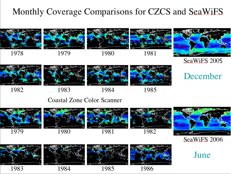
Although CZCS data was collected in nearly continuous alongtrack segments, early human screening of the orbital quicklook Laserfax images cut these segments into smaller, 2-minute files for subsequent Level-1 processing. Consequently, a great deal of CZCS data while collected on the spacecraft, was never processed beyond Level-0 as it was deemed unsatisfactory due to cloud cover, lack of ocean coverage or other reasons. Numerous reanalyses of the Laserfax were done towards the end of the mission to try and recover as much useful data as possible which significantly increased the number of scenes ultimately available. Finally, toward the end of the mission as the instrument's behavior was more problematic, CZCS was given the highest priority for data collection with the goal of trying to obtain as close to a contemporaneous global data set of ocean color as possible. The maps below show the monthly coverage for December and June throughout the CZCS mission life as compared to a representative December and June from SeaWiFS. You can see how patchy the coverage was both in time and space and that large portions of the Southern Ocean in particular, were rarely sampled. You can also see the increase in coverage at the very end of the mission in June 1986 as a result of the dedicated sampling effort. The CZCS was turned off in late June 1986 at the start of the low power season with the intention of turning it back on in December 1986 when power conditions would be more favorable. However, attempts to reactivate the CZCS in December 1986 met with failure and it was officially declared non-operational on 18 December 1986.
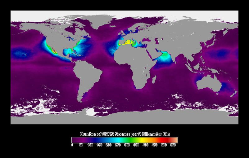
The image below shows the mission-long sampling density for the CZCS. It is very clear from this image that it really was a COASTAL ZONE color scanner with heavy emphasis on sampling being given to the coastal waters, and primarily those in the northern hemisphere. Although persistent cloud cover in regions like the Intertropical Convergence Zone and other factors influence the patterns of coverage, and since the CZCS was scheduled to take data over specific regions rather than follow a more uniform global distribution of sampling as is the case with SeaWiFS and MODIS, the impact of this selection can be easily seen. However, one must remember that environmental awareness was just coming of age in the 70's at the time of the CZCS mission and that most people's attentions were focused along the coasts and the concern was focused on what impact humankind was having in these regions. The decades of the 80's and 90's saw the focus shift to a more global approach to environmental studies.