
 Science Quality SeaWiFS Data for Global Biosphere Research
Science Quality SeaWiFS Data for Global Biosphere Research
Science Quality SeaWiFS Data for Global Biosphere ResearchNASA/Goddard Space Flight Center Greenbelt, MD 20771
as published in Sea Technology
September 1998, pages 10-16
The Sea-viewing Wide Field-of-view Sensor (SeaWiFS; Hooker et al., 1992) has been operational since September 18, 1997 and has been providing global estimates of oceanic chlorophyll-a and other bio-optical quantities to the international research community since then. These data are critical for understanding the temporal variability of marine ecosystems, especially with regard to events such as El Niqo and La Niqa, and the role of oceanic photosynthesis and primary productivity in the Earth's carbon budget and climate (Falkowski et al., 1998). The data are also proving invaluable for fisheries and coastal zone management (Vance et al., 1998). In addition, because the sensor does not saturate over clouds and land, applications are being explored for use in the atmospheric and terrestrial sciences.
SeaWiFS is a cost-sharing collaboration between NASA and Orbital Sciences Corporation (OSC) wherein NASA Goddard Space Flight Center (GSFC) specified the data attributes and bought the research rights to these data, maintaining insight, but not oversight, of OSC. The SeaWiFS Project at GSFC is responsible for the calibration, validation, and routine processing of these data. OSC provided the spacecraft, instrument, and launch, and is responsible for spacecraft operations for five years at a fixed price, while retaining the operational and commercial rights to these data. In order to protect OSC's data rights, the release of research data is delayed, unless near-real time access is necessary for calibration and validation activities. In late December, the SeaWiFS Project completed its evaluation of the data (data volume, radiometric quality, navigation accuracy, etc.) and determined that the data met all of the contractual specifications
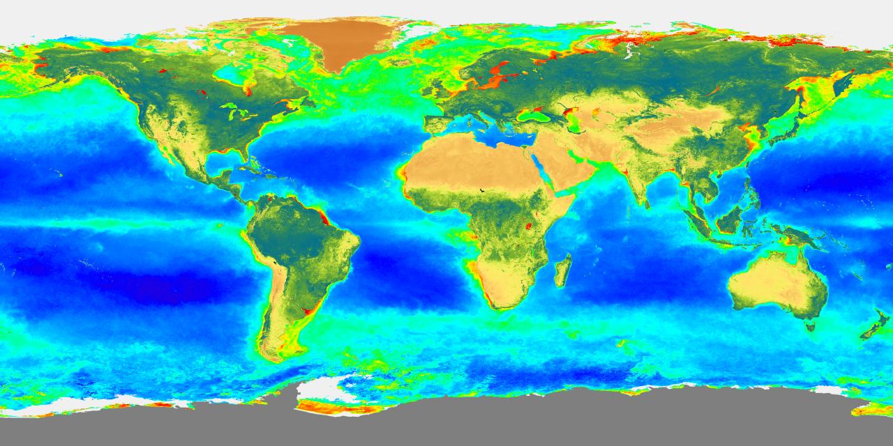
Satellite ocean color research began with the proof-of-concept Nimbus-7 Coastal Zone Color Scanner (CZCS) which collected data on an irregular temporal and spatial basis from November 1978 to June 1986. Despite coverage limitations (McClain et al., 1993) and severe degradation in the sensor's sensitivity (Evans and Gordon, 1994), the mission produced a substantial volume of published scientific results on marine ecosystem dynamics, which prompted the U.S. to launch SeaWiFS as a component of the NASA Earth Observing System (EOS). SeaWiFS collects global data (oceans and land) every two days and is the first mission capable of monitoring the global biosphere. Figure 1 is a composite of the September-December ocean chlorophyll-a concentrations (an operational archive product) and terrestrial normalized difference vegetation index (NDVI; a non-archived evaluation product).
The accuracy goals of the SeaWiFS mission are 135% for chlorophyll-a in Case 1 waters (reflectance dominated by pigment absorption) and 15% for water-leaving radiances, Lw, at 412, 443, 490, 510, 555, and 670 nm. These requirements are beyond the contractual data quality specifications as they involve products derived from the satellite data. Since operations began, a number of improvements in the processing code and algorithms for navigation, calibration, quality control, and atmospheric correction have been implemented. Based on the results of the initial validation last fall, a reprocessing of all data was initiated in mid-January, and completed by mid-February 1998. Subsequent to that reprocessing, it was determined from the lunar and solar calibration data that the 765 nm and 865 nm bands, both used for the atmospheric correction, were slowly degrading and producing artifacts in the derived products. Thus, a second reprocessing was undertaken in August and also included further refinements in the atmospheric correction and chlorophyll-a algorithms. As shown below, the data products can now be considered of sufficient quality for research and publication.
Before validation can be undertaken in a rigorous manner, the ability to geographically locate the data to within one pixel (roughly 1 km at nadir) must be verified. The OrbView-2 spacecraft navigation is a self-contained system, with complete information about the attitude of the spacecraft and its orbital position integrated into the downlinked data stream. Orbit determination is provided by on-board Global Positioning System (GPS) receivers. This system represents the first operational application of GPS technology to an orbiting Earth scanner, and functions without any additional ground or space tracking information. The GPS receivers yield 100 m position accuracy (after ground postprocessing). After launch, considerable effort to refine spacecraft instrument alignment information and spacecraft attitude determination in the ground processing software enabled the attainment of 1-2 pixel accuracy in geographically located Earth pixels throughout most of the orbit.
Because the CZCS mission did not have an extensive postlaunch validation program, which ultimately limited the use of the data for some important scientific applications, an extensive calibration and validation program was developed for SeaWiFS (McClain et al., 1992). Prelaunch calibration and validation activities are documented in detail in the SeaWiFS Technical Report Series (e.g., Barnes et al., 1994a, 1994b) and are summarized in Hooker and McClain (1998). Of particular importance to the postlaunch validation are the field measurement protocols (Mueller and Austin, 1995), the SeaWiFS Bio-optical Archive Storage System (SeaBASS; Hooker et al., 1994), and the calibration round-robins (Johnson et al., 1996).
The postlaunch calibration uses data from SeaWiFS solar and lunar measurements (Woodward et al., 1993; Barnes and Eplee, 1996) and vicarious calibrations using ocean surface measurements. Solar calibrations are collected daily and are used to detect sudden changes in instrument performance (they cannot be used for long-term trends because of the slow deterioration in the diffuser surface); thus far, no abrupt anomalies in sensor performance have been detected. Lunar calibrations are executed monthly by rotating the entire spacecraft and scanning the moon which has a nearly constant reflectance (libration effects cause the integrated radiance to vary by approximately 11%). Lunar calibrations can be used to monitor the absolute calibration stability of the sensor and only gradual changes in bands 7 and 8 have been observed. Time-dependent corrections for these changes have been incorporated into the processing.
The SeaWiFS vicarious calibration uses field measurments of Lw from the Marine Optical Buoy (MOBY; Clark et al., 1997) positioned off Lanai, Hawaii, in optically clear water (Figure 2) and under a predominantly marine-haze atmosphere, to adjust the calibration to obtain the "correct" Lw values for simultaneous and coincident (match-up) data. The vicarious calibration only works for bands 1-6, but not for the two near-infrared bands at 765 nm and 865 nm, which are used for the estimation of aerosol radiance and are assumed to have zero Lw values (Gordon and Wang, 1994). For the present time, the prelaunch calibration at 865 nm is assumed and the calibration at 765 nm is adjusted to yield a global open ocean (depth 1000 meters) average (765,865) value approximately equal to 1.0 typical of marine haze aerosols. A 4.4% decrease in the 765 nm calibration was required.
The initial vicarious calibration was derived from 53 MOBY match-up data sets collected during the first seven months of operation. In this procedure, the calibration adjustment coefficient for each wavelength is determined by minimizing the mean difference between the satellite Lw values and the measured values. High resolution (1 km) SeaWiFS data are used and scan angles are limited to 145 . The 1 km data collection over the MOBY site is automatically scheduled and collected onboard the spacecraft, as is coverage over all validation experiments. The adjustment coefficients for bands 1-6 are (1.0137, 1.0003, 0.9698, 0.9904, 1.0003, and 0.9678) , respectively.
Global analyses of low pigment (satellite chlorophyll-a < 0.15) ocean open pixels from 8-day binned data are used to track trends in the data set. Table 1 summarizes the results of analyses of the five 8-day composites spaced evenly throughout the September, 1997 to June, 1998 period. The analyses show no discernible trend in any of the average normalized clear water-leaving radiances (Lwn; Gordon and Clark, 1981) and (765,865) values. The differences between the MOBY and global SeaWiFS clear water values is due to the fact that most of the SeaWiFS clear water values are from the central ocean gyres where chlorophyll values are typically lower than at the MOBY site and reflectances are greater.
Independent verification of the SeaWiFS products (Table 2) is possible using match-up data from a number of postlaunch bio-optical cruises. The Atlantic Meridional Transect (AMT, Figure 3) is a primary source of validation data (Robins et al., 1996). The U.S. participation is established through a formal memorandum of understanding between the SeaWiFS Project and the Plymouth Marine Laboratory (UK). After screening the data set using a number of quality control criteria, only about 1.4% and 5%, respectively, could be used for comparison (Table 3). Turbid water cases are not included in the analysis because high reflectance waters are known to introduce errors in the estimation of aerosol radiance and, subsequently, the Lw values. In July, the SeaWiFS Project conducted a field experiment with the European Community Joint Research Center (G. Zibordi, principal investigator) in the northern Adriatic Sea to examine this and other related issues. The low percentage of usable stations underscores the difficulty in validating satellite ocean color products, the extreme care that must be taken in collecting these data, and the need for collaboration between ocean color missions to share data and cooperate in the validation process. These results show that the Lw and chlorophyll-a (O'Reilly et al., 1998) retrievals are within the accuracy goals stated above for Case 1 waters.
In conclusion, the initial validation results demonstrate that (1) the SeaWiFS sensor has been reasonably stable over the first year of operation with gradual changes in some wavelengths being accurately quantified using solar and lunar calibration data, (2) the vicarious calibration approach using MOBY data results in consistent global water-leaving radiances, and (3) the products meet the accuracy goals over a limited, but diverse, set of open ocean validation sites. These results also implicitly underscore the benefits derived from the SeaWiFS measurement protocols, the calibration round-robins, the bio-optical algorithm working group, and other prelaunch activities which have made these comparisons feasible so early in the SeaWiFS mission. SeaWiFS data is available to research users through the GSFC Distributed Active Archive Center (DAAC).
For more information, see the SeaWiFS home page /SeaWiFS/
Barnes, R. A., A. W. Holmes, W. L. Barnes, W. E. Esaias, C. R. McClain, and T. Svikek, SeaWiFS Prelaunch Radiometric Calibration and Spectral Characterization, NASA Tech. Memo. 104566, Volume 23, S. B. Hooker, E. R. Firestone and J. G. Acker (eds.), NASA Goddard Space Flight Center, Greenbelt, Maryland, 55 pp., 1994b.
Barnes, R. A., and R. E. Eplee, The SeaWiFS Solar Diffuser, In: Barnes, R. A., E-n. Yeh, and R. E. Eplee, SeaWiFS Calibration Topics, Part 1, NASA Tech. Memo. 104566, Volume 39, S. B. Hooker and E. R. Firestone (eds.), NASA Goddard Space Flight Center, Greenbelt, Maryland, 54-61, 1996.
Clark, D., H. R. Gordon, K. J. Voss, Y. Ge, W. Broenkow, and C. Trees, Validation of atmospheric correction over the oceans, J. Geophys. Res., D14(102), 17,209-17,217, 1997.
Evans, R. H. and H. R. Gordon, CZCS "system calibration": A retrospective examination, J. Geophys. Res., 99(C4), 7293-7307, 1994.
Falkowski, P. G., R. T. Barber, and V. Smetacek, Biogeochemical controls and feedback on ocean primary production, Science, 281, 200-206, 1998.
Gordon, H. R. and D. K. Clark, Clear water radiances for atmospheric correction of Coastal Zone Color Scanner imagery, Appl. Opt., 20, 4175-4180, 1981.
Gordon, H. R. and M. Wang, Retrieval of water-leaving radiance and aerosol optical thickness over the oceans with SeaWiFS: a preliminary algorithm, Appl. Opt., 33(3), 443-452, 1994.
Hooker, S. B., W. E. Esaias, G. C. Feldman, W. W. Gregg and C. R. McClain, An Overview of SeaWiFS and Ocean Color, NASA Tech. Memo. 104566, Vol. 1, S. B. Hooker and E. R. Firestone, eds., 24 pp., NASA Goddard Space Flight Center, Greenbelt, Maryland, 1992.
Hooker, S. B., C. R. McClain, J. K. Firestone, T. L. Westphal, E.-n. Yeh, and Y. Ge, The SeaWiFS Bio-optical Archive and Storage System, NASA Tech. Memo. 104566, Volume 20, S. B. Hooker and E. R. Firestone (eds.), NASA Goddard Space Flight Center, Greenbelt, Maryland, 40 pp., 1994.
Hooker, S.B., J.W. Brown, and A.D. Kirwan, Jr., Detecting "dipole ring" separatices with zebra palettes, IEEE Trans. Geosci. Remote Sensing, 6, 1306-1312, 1995.
Hooker, S., and C. R. McClain, A comprehensive plan for the calibration and validation of SeaWiFS data, submitted to Prog. Oceanogr., 1998.
Johnson, B. C., S. S. Bruce, E. A. Early, J. M. Houston, T. R. O'Brien, A. Thompson, S. B. Hooker, and J. L. Mueller, The Fourth SeaWiFS Intercalibration Round-Robin Experiment (SIRREX-4), May 1995, NASA Tech. Memo. 104566, Volume 37, S. B. Hooker and E. R. Firestone (eds.), NASA Goddard Space Flight Center, Greenbelt, Maryland, 65 pp., 1996.
McClain, C. R., W. E. Esaias, W. Barnes, B. Guenther, D. Endres, S. B. Hooker, B. G. Mitchell and R. Barnes,, SeaWiFS Calibration and Validation Plan, NASA Tech. Memo. 104566, Vol. 3, S. B. Hooker and E. R. Firestone, eds., NASA Goddard Space Flight Center, Greenbelt, Maryland, 41 pp., 1992.
McClain, C. R., G. C. Feldman and W. E. Esaias, Biological Oceanic Productivity, In the Atlas of Satellite Observations related to Global Change, R. Gurney, J. L. Foster and C. L. Parkinson (eds.), Cambridge University Press, New York, 251-263, 470 pp., 1993.
McClain, C. R., R. H. Evans, J. W. Brown, and M. Darzi, SeaWiFS quality control masks and flags: initial algorithms and implementation strategy, In: McClain, C. R., K. Arrigo, W. E. Esaias, M. Darzi, F. S. Patt R. H. Evans, J. W. Brown, C. W. Brown, R. A. Barnes, L. Kumar, SeaWiFS Algorithms, Part 1, NASA Tech. Memo. 104566, Volume 28, S. B. Hooker, E. R. Firestone and J. G. Acker (eds.), NASA Goddard Space Flight Center, Greenbelt, Maryland, 45 pp., 1995.
Mueller, J. L., and R. W. Austin, Ocean Optics Protocols for SeaWiFS Validation, Revision 1, NASA Tech. Memo. 104566, Volume 25, S. B. Hooker and E. R. Firestone (eds.), NASA Goddard Space Flight Center, Greenbelt, Maryland, 67 pp., 1995.
O'Reilly J. E., S. Maritorena, B. G. Mitchell, D. A. Siegel, K. L. Carder, S. A. Garver, M. Kahru and C. R. McClain. Ocean color chlorophyll algorithms for SeaWiFS, J. Geophys. Res., in press, 1998.
Robins, D. B., A. J. Bale, G. F. Moore, N. W. Rees, S. B. Hooker, C. P. Gallienne, A. G. Westbrook, E. Maraqsn, W. H. Spooner, and S. R Laney, AMT-1 Cruise Report and Preliminary Results, NASA Tech. Memo. 104566, Volume 35, S. B. Hooker and E. R. Firestone (eds.), NASA Goddard Space Flight Center, Greenbelt, Maryland, 87 pp., 1996.
Vance, T. C. et al., Aquamarine waters recorded for first time in eastern Bering Sea, EOS, Trans. Am. Geophys. Union, 79(10), 121, 1998.
Woodward, R. H., R. A. Barnes, C. R. McClain, W. E. Esaias, W. L. Barnes and A. Mecherikunnel, Modeling of the SeaWiFS Solar and Lunar Observations, NASA TM 104566, Vol. 10, S. B. Hooker and E. R. Firestone (eds.), NASA Goddard Space Flight Center, Greenbelt, Maryland, 26 pp., 1993.
Parameter   SeaWiFS 8-day Global          MOBY Data
                  Data Mean                 Mean
            (Standard Deviation)    (Standard Deviation)

E(765,865)	1.03 (0.02) 	  	    N/A
Chlorophyll-a	0.088 (0.014)	            N/A
Lwn(412)	1.93 (0.26)		1.68 (0.17)
Lwn(443)	1.73 (0.18)		1.47 (0.13)
Lwn(490)	1.17 (0.07)		1.01 (0.08)
Lwn(510)	0.68 (0.04)		0.60 (0.05)
Lwn(555)	0.28 (0.02)		0.26 (0.03)
Lwn(670)	0.02 (0.01)		0.02 (0.003)
Note:The 5 SeaWiFS 8-day global level-3 composites averaged 1.29 million low pigment open ocean bins. Lwn units are in W m-20sr-1 5m-1. The standard deviation values are computed from the 5 mean values. MOBY nominal clear water values are the average of 131 noontime values from different days. The MOBY data are provided by Dennis Clark and the MODIS Optical Characterization Experiment (MOCE) team.
Table 2. Statistics of the in situ (ship) and satellite comparison (match-up) data.
Parameter       Mean Ratio     Number of       Range of In Situ
              SeaWiFS/In Situ Observations         Values

Chlorophyll-a	  1.19		   12		[0.09, 1.06]
Lw(412)		  0.89	  	   23		[0.22, 1.76]
Lw(443)		  1.04	  	   23		[0.28, 1.55]
Lw(490)		  1.02	  	   23		[0.38, 1.06]
Lw(510)		  1.01	  	   23		[0.31, 1.00]
Lw(555)	          1.14	  	   23		[0.13, 0.49]
Note:Exclusion criteria included the following SeaWiFS masks
and flags (McClain et al., 1995): land, cloud/ice, sun glint, atmospheric
correction failure, high total radiance (values in the high range of the
bilinear gain), large solar zenith angle (70 ), large spacecraft zenith
angle (56 ), coccolithophore, negative Lw (bands 1-5), and Lwn(555) < 0.15
W m-2 sr-1. Time windows of 12 hours and 14 hours were applied for
radiometric and chlorophyll comparisons, respectively. A minimum of 5 of 9
pixels around a station had to pass all the exclusion criteria. Also, the
difference in the solar zenith angles between the times of the SeaWiFS
overpass and the observation was restricted to less than 15 .0
Table 3. Match-up data set sources
Principal Investigators Location Number of Measurements Lw,ChlorophyllNote: Both Lw and chlorophyll were not always provided at all stations.
S. Hooker, J. Aiken, North & South 5,4 & S. Maritorena Atlantic J. Mueller & C. Trees Gulf of California 2,0 D. Siegel & A. Michaels Bermuda 7,1 D. Clark & C. Trees Hawaii 2,2 R. Letelier & J. Bartlett HOTS site 2,0 A. Subramanian & J. Brock East U.S. coast 2,2 G. Mitchell & M. Kahru Southern California 3,3 Bight

 Rectangular Projection and Mollweide Projection
(4096 x 2048 jpg) [1.4 Mbytes]
Smaller version (1280 x 640 jpg) [150 kbytes]
Rectangular Projection and Mollweide Projection
 2. SeaWiFS chlorophyll-a concentrations around the Hawaiian Islands on
February 5, 1998. MOBY is the Marine Optical Buoy used for the vicarious
calibration of SeaWiFS. Areas of clouds and land are true color
composites of the total observed radiances at 412 nm, 510 nm, and 555 nm.
The selection criteria for the MOBY site were (1) uniformly low pigment
concentrations during all seasons, (2) noontime solar zenith angles never >
60 , (3) close proximity to a mooring support facility (the U. of Hawaii
provides space at the Sand Island harbor facility) and access to a
suitable vessel (the Moana Wave), and (4) reasonably low cloud cover
throughout the year. The Joint Global Ocean Flux Study (JGOFS) Hawaii
Ocean Time-series Station (HOTS) is also shown for reference.
2. SeaWiFS chlorophyll-a concentrations around the Hawaiian Islands on
February 5, 1998. MOBY is the Marine Optical Buoy used for the vicarious
calibration of SeaWiFS. Areas of clouds and land are true color
composites of the total observed radiances at 412 nm, 510 nm, and 555 nm.
The selection criteria for the MOBY site were (1) uniformly low pigment
concentrations during all seasons, (2) noontime solar zenith angles never >
60 , (3) close proximity to a mooring support facility (the U. of Hawaii
provides space at the Sand Island harbor facility) and access to a
suitable vessel (the Moana Wave), and (4) reasonably low cloud cover
throughout the year. The Joint Global Ocean Flux Study (JGOFS) Hawaii
Ocean Time-series Station (HOTS) is also shown for reference.
3. A subset of the global biosphere composite, centered on the AMT-5 cruise track, showing, in particular, the major circulation features of the North and South Atlantic Oceans. A zebra palette (Hooker et al., 1995) has been used to increase the contrast in the imagery across the different spatial scales inherent in the land and ocean pigment fields. Compare, for example, the equatorial and pole-ward regions of the North and South Atlantic with Figure 1 which uses a traditional (rainbow) gradient palette. It is the wide diversity of oceanic regimes sampled during each AMT cruise that makes the AMT Program so important for SeaWiFS validation.