If you look at the image on the preceding page for long enough, you will perhaps notice that it is not truly a perspective projection of the earth -- i.e. an astronaut peering through the window of her spacecraft would not see the Earth's features in that sort of spatial arrangement. Such perspective projections of SeaWiFS data are possible and have been produced, but, for a variety of reasons (lack of efficient mapping and interpolating software, desire to present single SeaWiFS scenes without the swath edge being too obvious, etc.), I do not always use a projection per se but rather rely on the SeaWiFS viewing geometry to give an image perspective.
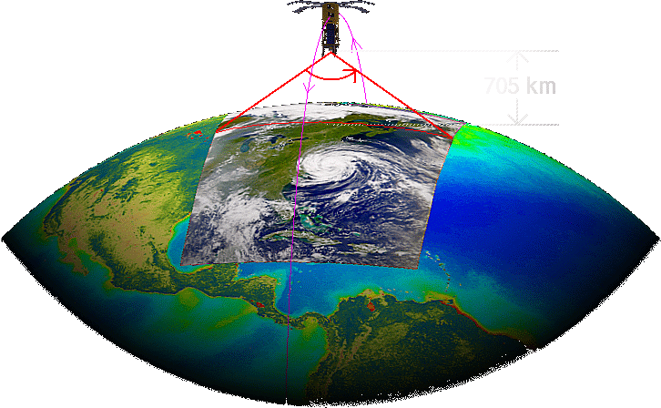
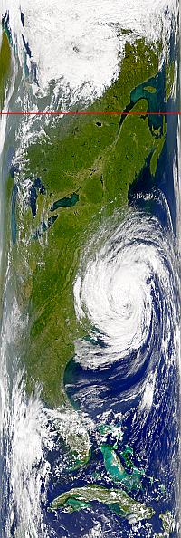
That viewing geometry is depicted in the diagram above. (The satellite itself is not to scale, but the rest of the diagram is.) A scaled-down version of the unmapped SeaWiFS swath is depicted at the right. The red line across the swath corresponds to the scan line depicted in the diagram above.
If you study the above diagram you can see that as the SeaWiFS telescope scans the planet's surface from west to east it sees different portions of the Earth along the scan at different angles. Pixels at the extreme western and eastern edges of the scan (the left and right edges, respectively, of the unmapped swath at left) are seen at highly oblique angles. If a person standing on the ground at one of those pixels were actually able to see the satellite, she would see it just ten to twenty degrees above the horizon. Near the center of the scan the telescope is looking almost straight down at the earth. (It does not look directly below the satellite because the telescope is normally tilted to avoid looking too close to the subsolar point on the earth.)
So, if you extract a section along the right side of the unmapped SeaWiFS image and rotate it counterclockwise (or extract a section along the left side and rotate clockwise), it will appear somewhat as if you are looking roughly eastward (westward) from a high vantage point as, for example, in the rotated extract below.
On the following pages, I present the specific, step-by-step procedure that I followed to take advantage of this effect when I produced the image on the previous page.