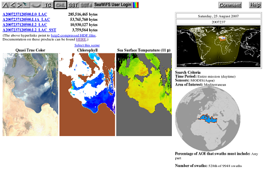
This type of page lets you step through your list of search results and view each scene at browse resolution. You arrive at this type of page by clicking on one of the thumbnails or filenames on the search results page or by starting a search that only finds a single scene.
Click on the various parts of the sample page layout below for a description of the functions of the various components.

Top of page
![]() Go up to search results or top level
Go up to search results or top level
If the result of your search was just a single swath,
then the up arrow returns you to the top-level,
search-specification
page. If your search found more than one
swath, then this arrow sends you to the
thumbnails
page that displays the particular subset of results
that includes the swath you are currently viewing. In
both cases all previously entered search parameters
are retained.
Top of page
![]() Go to more recent scene
Go to more recent scene
The left arrow takes you to the previous, more recent
(based on start time) scene in the list of search
results.
Top of page
![]() Go to earlierscene
Go to earlierscene
The right arrow takes you to the next, older (based
on start time) scene in the list of search results.
Top of page
![]()
![]() Highlight the search area on each browse scene
Highlight the search area on each browse scene
Click this button to toggle the highlighting of search areas on
(flashlight icon on) and off (flashlight icon off). Note that
the browse images will take a bit longer to appear when the
highlighting is turned on. This feature can also be toggled on
and off on the search results
page. Note also that all user search areas are first converted to lists
of quadsphere bins, so the edges of
highlighted regions will follow quadsphere bin boundaries.
If your search for scenes was initiated by clicking the
"Find swaths" button
without having specified any geographical region of interest
(i.e. your search area is the entire globe), then this button
will be deactivated and have a blurry appearance.
Top of page
![]()
![]() View all scenes or only your selected ones
View all scenes or only your selected ones
This button shows an open eye if you are only
interested in viewing the scenes that you have already
marked as having caught your
eye for some reason. A closed eye indicates that you
wish to view all scenes whether you interactively
singled them out or not. Click on the button to switch
between the two modes. If you have not yet marked any
of your search results as having caught your eye,
then this button will be inactive and will display
a blurry closed eye.
Top of page
![]() Switch to true color images (SeaWiFS only)
Switch to true color images (SeaWiFS only)
Clicking the "TC" button tells the web
interface to display quasi-True-Color both for the
thumbnail
images on the search
results page and for the
global map on the
top level page of this
interface (assuming that you return to the top level
by clicking on the up arrow.
The change to quasi-true-color will remain in effect
until changed again by the Chl, SST, or SST4 buttons. This
button is inactive if true color is already being
displayed or if none of the currently selected suite
of sensors include a true color product. Note that
there are no true-color images for MODIS at this
time. The only noticeable visual change on this
page will be that the small mapped scene in the
locator image will change to
true color if true color is available for the current
scene.
Top of page
![]() Switch to chlorophyll images
Switch to chlorophyll images
Clicking the "Chl" button tells the web
interface to display pseudocolor chlorophyll both for
the thumbnail
images on the search
results page and for the
global map on the
top level page of this
interface (assuming that you return to the top level
by clicking on the up arrow.
The change to chlorophyll will remain in effect until
changed again by the TC, SST, or SST4 buttons. This button
is inactive if chlorophyll is already being displayed.
The only noticeable visual change on this
page will be that the small mapped scene in the locator image will change to
chlorophyll.
Top of page
![]() Switch to 11 μm sea surface temperature images
(MODIS only)
Switch to 11 μm sea surface temperature images
(MODIS only)
Clicking the "SST" button tells the web interface
to display pseudocolor sea surface temperatures
derived from MODIS
11 and 12 μm bands both for
the thumbnail
images on the search
results page and for the
global map on the
top level page of this
interface (assuming that you return to the top level
by clicking on the up arrow.
The change to SST images will remain in effect
until changed again by the Chl, TC, or SST4 buttons. This
button is inactive if SST is already being
displayed or if none of the currently selected suite
of sensors include an SST product. Note that
there can be no SST imagery from the SeaWiFS sensor.
The only noticeable visual change on this
page will be that the small mapped scene in the
locator image will change to
SST if SST is available for the current scene.
Top of page
![]() Switch to 4 μm sea surface temperature images
(MODIS only, nighttime only)
Switch to 4 μm sea surface temperature images
(MODIS only, nighttime only)
Clicking the "SST4" button tells the web interface
to display pseudocolor Sea Surface Temperature both for
the thumbnail
images on the search
results page and for the
global map on the
top level page of this
interface (assuming that you return to the top level
by clicking on the up arrow.
The change to SST4 images will remain in effect
until changed again by the Chl, TC, or SST buttons. This
button is inactive if SST4 is already being
displayed or if none of the currently selected suite
of sensors include an SST4 product or if only daytime data have been selected
(the 4 μm bands are rendered unreliable by daylight). Note that
there can be no SST imagery from the SeaWiFS sensor.
The only noticeable visual change on this
page will be that the small mapped scene in the
locator image will change to
SST4 if SST4 is available for the current scene.
Top of page
![]()
![]() Access to SeaWiFS data
Access to SeaWiFS data
SeaWiFS data which are less than five years old have
certain restrictions on their distribution. Although
the entire SeaWiFS archive is viewable by
anyone in the form of browse images, only
authorized
SeaWiFS users may obtain the higher-resolution
level-1 and level-2 data from which the browse images
were made. This button provides access to those data
to authorized users who have been given a username and
password on our system. (Note that this password
is different from the one provided by the Goddard
DAAC.) Once a valid username/password has been
given, the browser will function exactly as before
with the exception that
SeaWiFS GAC and MLAC files in
our archive that are less than five years old will
be downloadable via individual
hyperlinks and the bulk
ordering process. If you are an authorized
user who has forgotten (or not yet been issued)
your username/password on our system, you may
request a new one.
Top of page
![]() Colorbars
Colorbars
The color-scale button fetches the legend that relates
color in the chlorophyll images to chlorophyll concentration
and the legend that relates color in the SST images to sea
surface temperature.
Top of page
![]() Leave Comments / Ask Questions
Leave Comments / Ask Questions
This button will drop you into the
Satellite
Data Access
section of the Ocean Color Forum where you may make any
comments or suggestions about the ocean color browser or
ask a question about something that is unclear to you.
The members of the
Ocean
Color staff routinely read these postings and
respond as appropriate.
Top of page
![]() Help
Help
This button takes you to the page you are currently reading.
Top of page
 Download scene
If we have the parent data online from which the displayed browse
images were created, then one or more of the filenames above the images
appear as hyperlinks to the corresponding
HDF4,
NetCDF-4/HDF5,
or — in the case of level-0 — raw
files, and the file
sizes in bytes are given to the right of the filenames.
The Level 0 (MODIS only), 1, and 2 HDF4 files in our archive have
been compressed with the bzip2 compression utility. This utility
freely available. If your system does not have this
utility, you may find it at:
http://sources.redhat.com/bzip2/.
For Windows users, a freely available utility,
7-Zip, can handle this format:
http://www.7-zip.org/.
The bzip2 compression format is a lossless format similar to the ubiquitious gzip format, but with an improved compression ratio. The table below shows the compression ratio for an example file:
| Compression Format | Size (megabytes) | Ratio |
|---|---|---|
| uncompressed | 206 | 1 |
| UNIX compress (.Z) | 86 | 0.42 |
| gzip (.gz) | 77 | 0.37 |
| bzip2 (.bz2) | 54 | 0.26 |
Files in the NetCDF-4 format (names ending with ".nc") are not separately compressed but use internal compression instead that is handled by the NetCDF/HDF software.
Some of our older level-1 files (e.g. SeaWiFS-GAC and OCTS) are still compressed with the LZW algorithm of the unix compress program. Such files are saved with a ".Z" extension.
Top of page
![]() Select/Deselect toggle
Select/Deselect toggle
If your search found more than one scene, then
you are provided with a hyperlink above the
browse images that allows you to further refine
the list of results by selecting or deselecting
the swath you are currently viewing. The effect
of clicking on the "Select..."
or "Deselect..." hyperlinks is
the same as the effect of clicking on the "****"
or "Yes" hyperlinks, respectively, on
the thumbnails page.
When a particular scene is selected the "Deselect..." hyperlink will be displayed with a green background. See also the eye button to control how you would like to step through a list of scenes that you have already performed some selection on.
Top of page
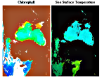
 Browse images
One or more views of the scene are displayed
at browse resolution in which pixels along the
vertical center line of the image are roughly 9
kilometers wide. The images that may be presented
include quasi-true-color, chlorophyll concentration,
and sea surface temperature. Which of these are
displayed depends on what is available for the swath
in question. (There are no SST images from SeaWiFS
data and currently no quasi-true-color images from
MODIS data. Land, clouds, and ice are masked with
brown and white in the chlorophyll images.
Top of page
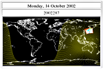
 Data day and locator map
To the right of the browse images, which are presented
in a satellite perspective i.e. unprojected, lies
a tiny projected version of the swath on a global
map for help in locating the swath in both time and
space. If the swath in question is a daytime (nighttime)
scene and spans the 180-degree (0-degree) meridian
then (in most cases) the projected version
will straddle two maps of the world; if it does
not span that meridian, then only one world map is
presented. (There are special cases involving swaths
that include a pole, that sometimes do not follow
this rule, but discussion of that is a bit lengthy
for presentation here.) Daytime scenes are displayed
on a map that extends from -180 to +180 degrees longitude.
Nighttime scenes are displayed on a map that extends from
0 to 360 degrees longitude. Each world map is labeled
above with a date in two forms. The first (top) form
should be readily recognizable. The second form of
the date is seven digits, YYYYDDD, where YYYY is the
year and DDD is the day of the year. Swaths can be
associated with one or two days. The date (or dates)
above the world maps show what those days are.
Note that these geographically determined data days
usually will match the dates
represented by the filenames.
This is not, however, always the case -- particularly for Aqua-MODIS
files immediately east of the data-day-dividing meridian or Terra-MODIS
files immediately west of the data-day-dividing meridian. (See
A2004202004000.L2_LAC
for an example of this discrepancy.)
The sunlit side of the planet at the time the swath was collected is highlighted in yellow.
Top of page
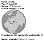
 Search Criteria
This portion of the page reminds you how you specified
your search for scenes. It also indicates where you
are in your list of search results (e.g. 276th of
419 swaths).
This information was last updated on 7 October 2014 by Norman Kuring.